 by Ann Martin
We’ve been using the AllTrails app for about 4 years and love it! It is great for seeing trails in a given area, planning a hike, then using its GPS function to keep us on the trail. There have been numerous times when we’ve been hiking and have lost the trail, especially in snow time, but AllTrails has reliably helped to get us back on track! THE BASICS AllTrails has a Free version and a Pro subscription, now called AllTrails+. AllTrails works on a phone, tablet, laptop or desktop computer. Download the app for your phone from the AppStore or Google Play. For your laptop or desktop go to https://www.alltrails.com. One login works on all devices and synchronizes all your data between devices. So, you can explore trails on your big screen, then access on your phone while on trail. The app shows trails for activities such as hiking, mountain biking, snowshoeing, and more. As an AllTrails member, you can:
AllTrails+ (paid subscription) allows you to:
OUR OPINION LIKES It’s an excellent planning tool. We love the little blue dot that is the GPS feature that has kept us on track while on poorly marked or confusing trails (or maybe it’s just us confused hikers!!) The reviews from other hikers give great insight and feedback about the trails. The directions to the trailhead have been very useful. CONSIDERATIONS The rating system of Easy, Moderate, Hard seems very subjective and there have been trails where we would not agree with the rating. Make sure to check the length, elevation gain, and description. We think a better rating system would be a 1-10 scale of difficulty. You have to use your laptop or desktop to create custom maps which can then be accessed on your phone. If you not expecting to have service on the trail, you have to open the app, download your map before starting and leave the app running. Leaving the app running will run down your battery - using an iPhone 8 we have never run out of battery even on a 6 hour winter hike, but it definitely runs it down. ***TIP: if you don’t need service while hiking, put your phone on ‘airplane mode’ to preserve battery life, the GPS will still work to guide you on your hike. CONCLUSION We highly recommend this app. Happy Hiking! https://www.alltrails.com/ Here is an overview: https://www.youtube.com/watch?v=oNWKK_f6xFQ
0 Comments
 by Majorie March
This app added so much to my summer of staying home and social distancing! I spent quite a lot of time wandering through the woods and fields and my back yard in the day-after-day sunshine. For some reason, I must identify everything I see and this summer I had the help of my new app, SEEK, created by iNaturalist, which is a product of National Geographic and California Academy of Sciences. It’s a free app, with information from the iNaturalist’s world-wide community. Once loaded onto my iPhone, it readily identified flowers, tree leaves, mushrooms, an insect or two, but not a bird that I pointed the camera at, probably because SEEK wants me to hold my phone close to the object and move it slowly over it for details. Hard to do with a bird. A small row of dots turn green as the app moves through the identification process. While identifying the Brown-eyed Susan, American Pokeweed, NewEngland Aster, and Interrupted Fern spot on, it struggled with the goldenrods and other asters. It identified an adorable tiny bee-like fly that hung around my compost bin and seemed to follow me around my yard as a Hover Fly, specifically a Maize Calligrapher (Toxomerus politus). Beyond identification, I have a record of the photo, when I observed it, and pictures of similar species. There have been 15 nearby and 3,466 worldwide observations of this insect and a graph shows me that it is seen from July into September, spiking in August. (I saw it on August 20.) Seek also offers Challenges and Achievements that I have not looked into. It tells me that I could, but have not observed any amphibians, fish, reptiles, arachnids, mollusks, mammals or birds yet.  by Hal March
The Gaia GPS app is free for download and use (at the basic level) for Apple IOS and Android. It offers 3 levels: 1. Basic user: free for 1 year. 2. Membership: 1 year $20.00 ($17.00 if join on Gaia website) or 5 years for $100.00 ($60 on the website) 3. Premium Membership: 1 year for $40.00 ($36.00 on website) 5 years for $200.00 ($160.00 on website) At the free level, downloading the app gives you the default Gaia Worldwide Topo, a color map which looks quite like a USGS Topo. It’s quite detailed, with contour lines, elevations, place names and so on. With this basic map you will be able to find your location, set a waypoint, plan a route, track your progress and take pictures at points on the way which will be added to your track. (On a mobile phone Gaia doesn’t need internet - cellular or WiFi - to profile GPS data to the app.) I chose the Gaia “Membership” to access all the maps they offer only at the Membership level or above. These maps, downloadable for offline use and printable for Membership, include USGS Topo, Satellite Topo, Outdoors Topo (hiking trails), Historic Topo 1930, Historic Topo 1900, Canada Topo and many others. The Premier Level offers hundreds more, but most of these (except the National Geographic Trail Illustrated Map) were maps that I didn’t expect to use, so I downloaded the app on my iPhone and paid the $17.00. This means I never tried to use the app at the Free level, but I think most of the main functions are the same. (If you’re unsure about paying for a higher level, Gaia will let you take a free trial.) The app has many settings and options, some not readily apparent. Using instructional articles and videos on their website and elsewhere, I’ve learned how to set a starting point, show my location and direction on the map, set waypoints, track my progress along trails and crazy (but virus free) bushwhacks. Gaia will also keep track of distance, elevation gain and so on. After finishing, you have the option of saving the trip, and - if you want - moving it into a folder. A nice bonus with Gaia GPS is the ability to let others share your routes or tracks. Another big plus is family members are free to use the app if they sign in with your ID. I’m having fun using this app, and it’s saved my bacon more than once!  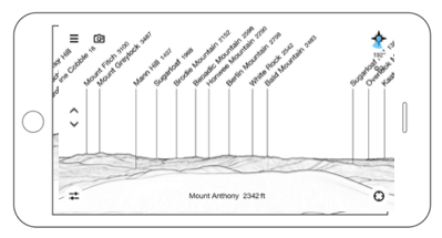 OK, you’re hiking with friends and get to an overlook and the conversation starts… “What is that mountain over there and what about that one in the distance?” “Is that Mount Snow?” “No, Snow is more that way, maybe it’s Haystack” “I think it must be…” “No, I think it’s…” And you all walk away not really knowing what you were looking at. Does this sound familiar? Your queries are solved with a neat little app named “Peak Finder”. Just hold your phone up and point it in the direction of the mountains you want to identify and you will see a panoramic drawing with peaks labeled. How cool is that? (View is what can be seen from the top of Mount Anthony.) 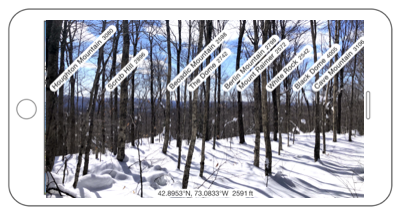 Now, you can click the ‘Camera Mode’ button and overlay the image of your camera with the panoramic drawing. (View is from Woodford area north of Route 9.) 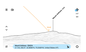 Other cool features:
You can also ‘telescope in’ to find less prominent peaks, adjust the compass setting, see the visibility range, ‘fly up’ to the mountain and see the views from the top, or see a list of all the mountains visible from your current location. While out in the wilderness, if you are confused about where you are, by knowing the name of the mountain seen you could orient yourself to the direction you want to walk. WOW! All this for $4.99. It’s the best bargain of the day. |
Access Octomono Masonry Settings
AuthorWrite something about yourself. No need to be fancy, just an overview. ArchivesCategories |
 RSS Feed